| The ZetaWare Advantage |
| Brochure ... | KinEx ... | Trinity ... | Products ... | Home ... |
How Is ZetaWare Different from Others?
In addition to the ease of use, capability to incorporate any kind of data, better geological QC and model building, outstanding technical support and training, the ZetaWare approach is more focused on honoring geology than the competition. We insist that the geological uncertainty of the models are the largest and need to be reduced or otherwise considered as scenarios. Other tools may allow more components in their kinetics or pvt models, they do not add any value as very often the source rock samples we have from the wells may not represent the source rock in the kitchen. We do not even know the source rock thickness in the kitchen accurately, let alone TOC and HI. The gross assumptions we make of the source rock properties and uncertainty in secondary migration losses will vastly overwhelm the small differences these unconstrained models make. Just like a fancier digital odometer will not improve the accuracy in predicting the time it will take to drive to downtown in a particular morning.
Our software distinguishes from others in many aspects. But the most important one is the ease of use. For example, Trinity is not only compatible with all the data formats, but it takes the guesswork out of data importing by automatically detecting files and import them properly. Just drop the file in Trinity, and that's it. We designed the software with the average explorationist in mind. Any new user can make a maturity map after spending less than 30 minutes with the online tutorial. Our user-friendly design and innovative features are being imitated (often poorly) by most of our competitors.
All the tools in Trinity takes minutes or seconds to run, so users can run multiple scenarios quickly to develop a risk profile for a prospect. What if the thermal gradient in the kitchen were lower than 10 percent? What if the source interval is half the thickness? What if the faults are leaking? etc. Even 3d migration scenarios take seconds to run, so user can test the risk of filling his prospect with higher migration loss factors, or an alternative source rock. Some other software may take hours (even days) to run a single simulation. At the end that waiting, the user may realize he forgot to tick one of the boxes and have to do this whole thing again!
- Paleo-bathymetry One of the problems with typical basin models is that the surface (sea bottom) is the starting point for the compaction and back stripping. However, without knowing paleo-bathymetry/topography, the models allow the crustal basement to completely deform based on sedimentation rates - geologically incorrect. This will result in wrong paleo structures which migration modeling is based upon, and wrong surface temperatures the maturation models are dependent upon. Trinity comes with built in tools for reconstructing paleo-bathymetry surfaces through time, so we can depend on having the correct paleo-structure maps and surface temperatures. Click here to see an example
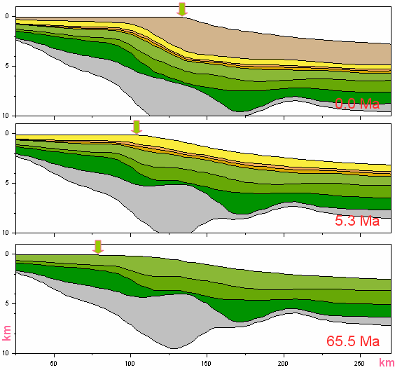
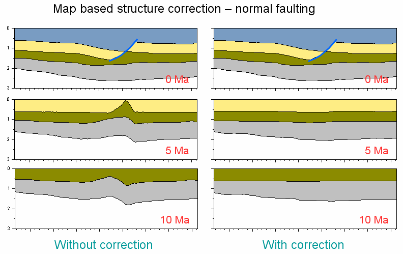
- Faults, thrust, Folds and Diapirs Most basin models assume vertical deformation only. When there is a normal fault, for example, vertical the thickness of the formation is thinned by the fault. Handling paleo-structures with only vertical compaction movement will result in a "ghost structure below the fault before the fault was in place. There are similar problems with thrust, folding, salt and shale diapirs. Trinity provides tools for automatically handling these problems so the paleo geometry of the basin is much closer to reality. Click here to see an example
- Unconformities Very often, modelers assume a constant erosion amount over the area or taken erosion estimates from well data and grid them into maps. These methods typically produce incorrect subsurface geometry which will result in incorrect paleo-structure and migration models. Trinity has built in tools to help create erosion maps that are geologically consistent with the basin geometry. The paleo structure restoration is much more realistic than the traditional methods. Click here to see an example
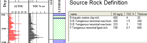
With other models, the source rock description is made by mixing different source types. In geological reality, there are vertical variations of source facies. A typical marine or deltaic source rock sequence will have interbeded layers of poor (low TOC and HI) source facies and usually thinner streaks of good source rocks. Mixing the source by percentages will result in the incorrect composition of fluids to be predicted. In a simple example of 20 meter 5% TOC 600 HI layer plus a 80 meter 2% TOC 150 HI layer, the 20 meter rich layer will expel oil at a lower temperature and the rest of the source will expel gas and condensate only. A "mixed" source by averaging the parameters will produce gas only. ZetaWare's tools allow unlimited number of interbeds of different source facies to be modeled in parallel - important in predicting the correct composition and GOR. An incorrect source rock description will lead to wrong fluid types regardless of how many components the kinetics model has.
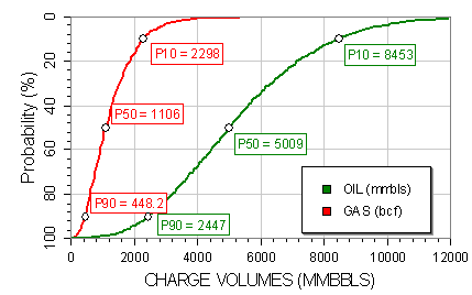
Trinity is still the only software tool that can risk map inputs of structure surfaces, source rock isopachs, lateral variation of thermal gradients, and fetch areas -- all in a less than a minute! The resulting charge volumes and GOR for a given prospect or basin will be a probability distribution.
Better Thermal Modeling Approach
Most of the others do their thermal modeling by calibrating a basement heat flow to match temperature and vitrinite reflectance data. Either the same heat flow or a heat flow map based on several calibration points is used to model hydrocarbon generation in the kitchen. This is a big source of error as heat flow varies with geology and the kitchen area where we have no well data will have a different heat flow (typically much lower) than the well locations on structure highs - and most wells are drilled on structure highs so they do not represent the kitchens!
The ZetaWare approach uses the wells to calibrate an effective crust thickness (geology). The geology then can be extrapolated in to the kitchen based on seismic and gravity data. The model will predict basement heat flow in the kitchen based on the differences in crustal thickness and sedimentation rates. Crust variations and sedimentation rate changes are dominant process that causes heat flow to vary laterally. Here is an example of this method from NW Australia
Trinity 3D comes with a shale gas modeling tool, which takes into account not only adsorption mechanism, but also predicts the amount of solution gas and free (compression) gas present in the shales and silt zones. The partitioning of the different phases of the gas is dependent on pvt behavior and the burial and uplift history. It maps the gas yields (scf/ton or mcf/section and other units) by taking into account all these geological factors. It also predicts if an area meets the minimum requirements for shale gas production.
We continue to innovate, by working with consortium companies, to deliver new and practical tools for reducing exploration risk. The software is typically updated once a month with new features. We can turn around with user request for new features in a matter of few days (some times hours). Our competitors typically update their software once a year, some even longer.
If you call us with a question, you will reach some one with more than 20 years of experience in petroleum system modeling. If you find a bug, request a new feature, you can talk directly to the software programmer, the geologist and the owner of the company all at the same time. We would be glad to provide references from many happy customers.
©2001, ZetaWare, Inc. All rights reserved