| Map Based Charge Risking |
| HOME | PRODUCTS | SUPPORT | UTILS | LINKS | ABOUT |
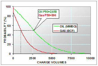
The volumes of charge for a petroleum prospect depends on the source rock properties (quality, richness, thickness and maturity). There are usually tremendous degree of uncertainty regarding source rock properties since we may not have a large number of wells penetrating the source interval. And some times we are not even sure of the existence of the source rock. The traditional deterministic basin modeling approach has been proven to be unreliable in providing a quantitative charge estimate. For this reason, most explorationists use a probabilistic approach to calculate a distribution of charge volumes to show the probability of an economical success for their prospects. A typical result shows the probability of oil or gas charge exceeding certain volumes:
Why Map Based Charge Risking
The thickness and maturity of the source rock may vary laterally within the fetch area. The variation of maturity is also controlled by the lateral geometry of geological structure. The variables hydrocarbon volumes are dependent upon are interdependent and such dependency is controlled by the geometric shape of the structure surfaces.
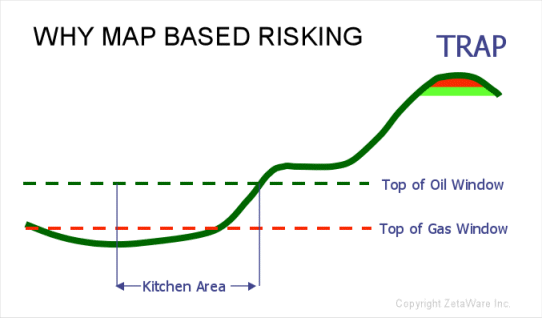
From this schematic figure, we can see that if the maturity of the kitchen is to increase either by a deeper burial or a higher thermal gradient, the mature area is bound to increase as well. As the maturity increases and the oil window moves upward in stratigraphy, the relative change in oil and gas charge also will a function of the source geometry. For these reasons, traditional charge risking tools (mostly developed as Excel plug-ins or a 1D approach such as BasinRisk) are mostly inadequate.
What can we do ?
Trinity is the only commercially available map based risking software. It combines the probabilistic approach and the modeling of the interdependencies among geological parameters to provide a realistic estimate of charge volumes. It captures the space and time depedencies among the above mentioned geological parameters by using maps as the input parameters (such as TOC, HI, thickness, depth, etc.) and runing as a 1D basin model at every grid node. With the proprietary Monte Carlo algorithms, 2000 simulations of the charge volumes for a typical fetch area takes only a few seconds. The results of the modeling provide:
- charge parameters for ranking prospects
- input for reserve risking and economic analysis
- determine the importance of geological parameters to charge risks
- regional resource evaluations
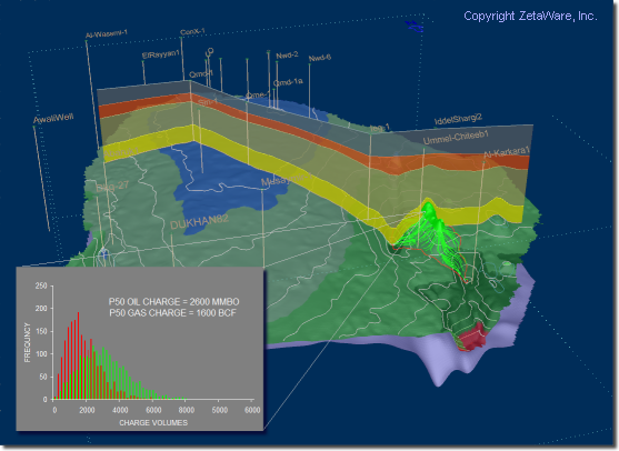
Trinity also provides interactive visulization of the 3D nature of the charge systems risked. The geology of the basin and charge risks for the prospect are in plain view.
What else ?
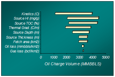
The figure below is one of the output options of the charge risking workflow. It shows how the geological parameters are ranked in order of their importance to charge risks in the area. It indicates that future work should be focusing on source rock kinetics data in order to further reduce the uncertainty in charge volume estimates.
References:
- Steven Crews, 2000, Advances in map-based and 1-D modeling: capturing space-time variations in heat flow, maturity, and source-rock properties for real-world charge risking, AAPG Gordon Conference on Organic Geochemistry.
- Robert E. Megill, 1984, An Introduction To Risk Analysis; Second Edition. pp. 273.
- Bishop, R. S., H. M. Gehman, Jr. and A. Young, 1983, Concepts for estimating hydrocarbon accumulation and dispersion, AAPG Bull., v67, p. 337-348.
- Sluijk D., and M.H. Nederlof, 1984, Worldwide geological experience as a systematic basis for prospect appraisal, in G. Demaison and R. J. Murris, eds., Petroleum Geochemistry and Basin Evaluation: AAPG Memoir 35, p. 15-26.
- White D., 1993, Geological risking guide for prospects and plays, AAPG Bull., v. 77, no. 12, p. 2048-2061.
- Rose, P. R., 1987, Dealing with risk and uncertainty in exploration: how can we improve?: AAPG Bulletin, v. 77, no. 3, p. 485-490 .
Copyright ©2003, ZetaWare, Inc. All rights reserved | Terms of use